Question
Question: (Street Plan): A city has two main roads which cross each other at the center of the city. These two...
(Street Plan): A city has two main roads which cross each other at the center of the city. These two roads are along the North-South direction and the East-West direction. All the other streets of the city-run parallel to these roads and are 200m apart. There are 5 streets in each direction. Using 1cm=200m, draw a model of the city on your notebook. Represent the roads/streets by single lines. There are many cross-streets in your model. A particular cross-street is made by two streets, one running in the North-South direction and another in the East-West direction. Each cross street is referred to in the following manner: If the 2nd street running in the North-South direction and 5th in the East-West direction meet at some crossing, then we will call this cross-street (2,5). Using this conversion, find:
(i) How many cross-streets can be referred to as (4,3)
(ii) How many cross-streets can be referred to as (3,4).
Solution
We know that if there are cross-streets referred to as (m,n), then that means the mth street running in the North-South direction and the nth street running in the East-West direction meet at some crossing.
Complete step by step answer:
Let us draw a model of the city as follows,
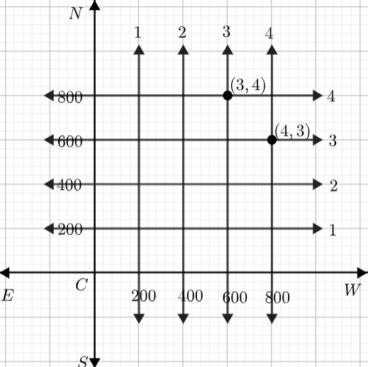
We can see many cross-streets in the model. We are asked to find
(i) the number of cross-streets that can be referred to as (4,3)
(ii) the number of cross-streets that can be referred to as (3,4)
So, as we can see, the 4th street running in the North-South direction and the 3rd street running in the East-West direction meet at (4,3). So, there is only one cross-street we can refer to as (4,3).
Similarly, we can see that the 3rd street running in the North-South direction and the 4th street running in the East-West direction meet at (3,4). So, there is only one cross-street we can refer to as (3,4).
Hence the cross-streets that can be referred to as (4,3) and (3,4) are uniquely found.
Note: As we know, the street plan is a map of a town or city, showing the position and names of all the streets. Here, we use a model of the city that contains streets in the North-South direction and East-West direction. The horizontal lines and the vertical lines we draw are the streets and if the lines meet at some points, then the streets are called cross-streets and referred to as the point at which they meet.